Can anyone provide some sample in ObjectScripts to import a tab separate txt file into a SQL table? I checked the document, there are two available classes, %SQL.Import.Mgr and %SQL.Until.Procedures, which one is better choice?
Thanks
Can anyone provide some sample in ObjectScripts to import a tab separate txt file into a SQL table? I checked the document, there are two available classes, %SQL.Import.Mgr and %SQL.Until.Procedures, which one is better choice?
Thanks
Hello everyone,
i want an automatic unidirectional syncronization of multiple databases (some tables from .dat file, not the whole .dat file) .
So far i have tried everything from package %SYNC and the best working class is SyncSet with journals and guids. The problem is initial database transport for example when i want to add another server. The easiest solution i have found is to transport syncing globals ^OBJ.SYNC.N to another database and then call %SYNC.SyncSet.Import(), however it seems not to work with only the global structure, although it works fine using import files.
... but let’s first take a look at two relatively small topics, and namely:
We only have one page for now. How about adding one more? Said - done.
Hi, Community!
You know, next Friday is a very famous Friday when every shop usually turns into Cinderella introduces unique deal proposals.
We are not the shop but we have a unique proposal for the next Friday on Global Masters.

I am trying to transform an Enlib.EDI.XML.Document through aXLT I know how to trans form the xml document through a xlt stylesheet but been trying to get an Enlib.EDI.XML. Document from a procees by creating aoperation that will do the transformation of this to file if this can be done in a process all ideas welcome so far I have come to this and I keep getting an error
:ERROR{ERROR #5002: Cache error: <PROPERTY DOES NOT EXIST>zXMLTOJson+6^TestEnvironment.Custom.GENERAL.CUSTOM.XLT.XMLToJsonOperation1.1 *Parameters,EnsLib.EDI.XML}Class XLT.XMLToJsonOperation1 Extends (Ens.BusinessOperation, EnsLib.XSLT.Transformer)
{ Parameter ADAPTER = "EnsLib.File.OutboundAdapter"; Property Adapter As EnsLib.File.OutboundAdapter; /// Style sheet to convert Message to Json
Property XLTStyleSheet As %String(MAXLEN = ""); Parameter SETTINGS = "XLTStyleSheet:Basic"; Parameter INVOCATION = "Queue"; /// Default operation is to use a TransformationRequest to transform the input XML into the output
Method XMLTOJson(pRequest As EnsLib.EDI.XML.Document, Output pResponse As EnsLib.XSLT.TransformationResponse) As %Status
{
Set tSC=$$$OK,$ZT="Trap"
do {
// Grab the input content and the stylesheet key
Set tInput = pRequest
Set tSSKey = ..XLTStyleSheet
Set tSC = ..Transform(tInput,tSSKey,pRequest.Parameters,.tOutput)
If $$$ISOK(tSC) {
Set pResponse = ##class(EnsLib.XSLT.TransformationResponse).%New()
Set pResponse.Content = tOutput
}
} while (0)
Exit Quit tSC
Trap Set tSC=$$$ERROR($$$CacheError,$ZE) Goto Exit
} XData MessageMap
{
<MapItems>
<MapItem MessageType="EnsLib.EDI.XML.Document">
<Method>XMLTOJson</Method>
</MapItem>
</MapItems>
} }Anxious about starting your first major REST application? Don't fret! Join Michael Smart, Senior Support Specialist at InterSystems, as he explores the principles of RESTful design and covers best practices for creating flexible, robust, and intuitive REST services.
Watch the webinar and access the sample code.
Still have questions? Ask them in the comments section below!
Hi, Community!
Please find a new session recording from Global Summit 2017:
Hello I'm Minsu
I want to develop web program like community with Spring Framework and Caché. but I have experience only with MySQL.
A. Can I use Caché with Spring Framework?
B. If I can, How?
Thank you guys.
Hi community ,
i come back to you , i've a problem with Client description in Oauth2, when i tick the Supported grant types and i save , there are not registred on the OAuth2_Client.Metadata table .
can you tell me where is the problem please.
you will find attached a screenshot.
thank's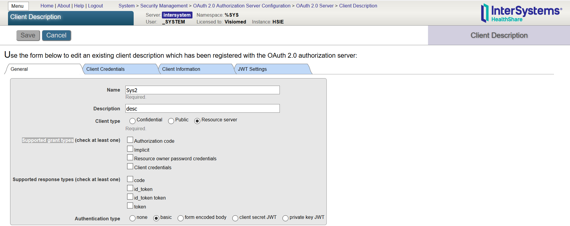
Hi Team,
How to we get a data from http response using HHTP request.Give one Example.
Thanks ,
Ponnumani Gurusamy.
HI,
We are using Cache 5.0.15 version. We are facing
Thanks in Advance! Sankar
Hi,
We currently have individual systems connecting to MESH, but would like to leverage the monitoring and managment facilities in HealthShare.
Has anyone integrated directly with MESH?
https://digital.nhs.uk/message-exchange-social-care-health/technical-in…
Kind regards,
Stephen
Apologies if this has been asked already but I was not able to find it. When I look at the Add/Edit screen I see authentication methods of Password and Kerberos and am wondering if passing an identify file is supported.
I'm using Client 2017.1.1 Build 111, thanks!
Hello Community,
I recently encountered a issue with Caché and I can't figure out where the problem is coming from.
I noticed that the license limit (200) was reached whenever I was opening my Studio (so it seems). When this occurs, I restart Caché (with the Cube in the Taskbar), and the number of license used is back to 1%, but grows back after. The time taken before the number of license grows back again looks pretty random.
Here is a couple of screenshots :

Does anybody know where the problem might come from ?
Hello everyone. So as title says, I used to install Eclipse with Atelier plugin recently to work in instead of Cache Studio and spotted that all my JS-code on CSP page is colored green as you can see here:
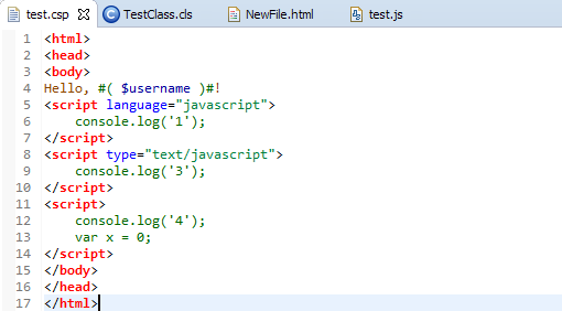
I couldn't find how to make code-detection on CSP files like JS files. All I found is this element which controls code inside HTML tag <script></script>
..which can't help me to color for example var to be pink color and etc. Any solutions?
Problem:
I want to be able to import XML (say, using %XML.Reader) to Caché objects permissively (ignoring invalid/unexpected tags/attributes), but also to validate the same XML and list any/all invalid tags/attributes that it contains.
I have a business operation which I want to run an d I keep getting the above error have tried trace and logging every stage but can not figure out why the error comes from I am expecting this service to run everytime it is called hence the implementation so could anyone help out please
Operation
Class XmlToJsonOperation Extends (Ens.BusinessOperation, )
{
Parameter ADAPTER = "EnsLib.File.OutboundAdapter";
Property Adapter As EnsLib.File.OutboundAdapter;
Parameter INVOCATION = "Queue";
Property CompiledStyleSheet As %XML.XSLT.CompiledStyleSheet;
/// Style sheet to convert Message to Json
Property XLTStyleSheet As %String(MAXLEN = "");
Parameter SETTINGS = "XLTStyleSheet:Basic";
Method XmlToJson(pRequest As EnsLib.EDI.XML.Document, Output pResponse As Ens.Response) As %Status
{
 set tSC=$$$OK

    set oInStream = ##class(%Library.GlobalCharacterStream).%New()

    set outputiing =##class(%Stream.FileCharacter).%New()

    set tSC  = pRequest.OutputToLibraryStream(oInStream)

    if ($$$ISOK(tSC))
    {
     $$$TRACE("we in the if")
     $$$LOGINFO("we in the if")
   do ..OnInit()
   $$$LOGINFO("we in OnIT")
   set outputiing= ..getJSON(oInStream)
   $$$LOGINFO("On The Stream")
  set fileName="json.txt"
  set tSC=..Adapter.PutStream(fileName,outputiing)
 }
 Quit $$$ERROR($$$NotImplemented)
}
XData MessageMap
{
<MapItems>
 <MapItem MessageType="EnsLib.EDI.XML.Document">
  <Method>XmlToJson</Method>
 </MapItem>
</MapItems>
}
/// This user callback method is called via initConfig() from %OnNew() or in the case of SOAP Services from OnPreSOAP()
Method OnInit() As %Status
{

 set tXSL=..XLTStyleSheet ;; file path from parameter
 Set tSC=##class(%XML.XSLT.CompiledStyleSheet).CreateFromFile(tXSL,.tCompiledStyleSheet)
    set ..CompiledStyleSheet=tCompiledStyleSheet

    $$$TRACE("compliled sheet name"_..CompiledStyleSheet)
    $$$LOGINFO("gone pass the trace compile")
 Quit $$$OK
}
Method getJSON(inStream As %Stream)
{
 set tSC=$$$OK
 set tSC=..CompiledStyleSheet
  if ($$$ISERR(tSC))
   {
  $$$LOGINFO("Error on the Complied sheet")
  $$$LOGINFO(tSC)
 }
 set tSC=inStream

  if ($$$ISERR(tSC))
   {
  $$$LOGINFO("Error on the instream")
  $$$LOGINFO(tSC)
 }
 Set tSC=##class(%XML.XSLT.Transformer).TransformStreamWithCompiledXSL(inStream,..CompiledStyleSheet,.tOutput)
 If ($$$ISERR(tSC))
 {
  $$$LOGINFO("Error on the getJson")
  $$$LOGINFO(tSC)
 }

 quit tOutput
}
}In this article I'd like to discuss asynchronous REST and approaches to implementing it.
Why do we need asynchronous REST? Simply put - answering the request takes too much time. While most requests usually can be satisfied immediately, some can't. The reasons are varied:
The solution to these problems is asynchronous REST. Asynchronous REST works by separating request and real response. Here's an example, let's consider the following simple async REST broker:
Hello,
I am looking to format my email into a few line breaks etc...is there a tutorial for this I have missed? Thanks!
Eventually, I would like to format like below:
Hi, community
i am defining a new role on my system , i want that this role has access only to my own data base , do you konw which roles can i add to this one ?
thank you
Hi, I'm a student, weak programming. I ask for your help, I write a program in C #, there are two tables, but I do not understand how to organize the connection between them many to many. Table in DataGridView1 from DataSet1 on Form1 key connection in DataGridView1 from DataSet1 to Form3
I do this on Form1
private void dataGridView1_CellDoubleClick(object sender, DataGridViewCellEventArgs e)
{
if (e.RowIndex >= 0)
{
DataGridViewRow row = this.dataGridView1.Rows[e.RowIndex];
Form1.IDfor3form = row.Cells[1].Value.ToString(); // By the Bilet column
Form3 c = new Form3();
c.Owner = this;
c.Show();
}
}Hi community,
my database (HSAUDIT) is only on the read mode , how can i pass to the Read/Write mode?
thank's
Hi,
I was wondering if there is a way to get a copy of Cache for personal usage and development.
Regards
Kumar
Has anyone tried adding syntax highlighting to GitHub for Caché CLS files?
Looking at the list of supported languages and extensions...
https://github.com/github/linguist/blob/master/lib/linguist/languages.yml
It looks like Mumps is supported, and there is also an existing language with a .cls extension, which would account for why I see some very odd highlighting going on with some of my code.
There is a page on contributing a new language here...
https://github.com/github/linguist/blob/master/CONTRIBUTING.md
Hi,
I'm trying to use the IN operator in SQL.
does not work, can anyone tell me why that could be?
for example:
SELECT * FROM TafnitCore_Logistics_TransferPackage_DB.PackageData WHERE ID IN ('1||1||9852553062' , '1||1||9852553061' ) ORDER BY Building
And I get the following error:
SQL
|
Regards,
Nael
What type of tree traversal was we are using in our Cache database?. Please explain anyone.
Thanks in Advance!
sample
    w "Total No.Of Sticks:21"_!
    s sticks=21
    r "enter machine name: ",a
    r "enter dev name: ",b
    w "Display 1 to 21 sticks"_!
    s i=""
    f i=1:1:21{
        w " "_i_" "
    }
user(sticks)
    w !_"User select 1 or 2 or 3 or 4 sticks:"_!
    r "User enter sticks: ",us
    if us>4 {
        w "please select upto 4 Sticks"
        r "User enter sticks: ",us
    }
    s cnt=sticks-us
    s sticks=cnt
    f i=1:1:sticks {
        w " "_i_" "
    }
    s dev=1
    s machine=0
    d:sticks=0 lost(dev,machine)
    d machine(.sticks,us)
    q
machine(sticks,us)
    w !_"Machine select 1 or 2 or 3 or 4 sticks: "_!
    s ms=5-us
    w "machine Pick the Sticks:"_ms
    hang 1
    s cnt=sticks-ms
    s sticks=cnt
    f i=1:1:sticks {
        w " "_i_" "
    }
    s dev=0
    s machine=1
    d:sticks=0 lost(dev,machine)
    q:sticks=0
    d user(.sticks)
    q
lost(dev,machine)
    if dev=1 {
        w "User Lost"_!
    }else {
        w "machine Lost"_!
    }
    r "restart your game Yes(Y) or No(N)",res
    if res="Y" {
        d sample
    }else{
        q
}I set column onclick event, but it is not working
S col = ##class(%ZEN.Auxiliary.column).%New()
S col.header = "Header"
S col.colName = "Data3"
S col.onclick = "alert('ok');"
D table.%AddColumn(col)
alert Ok is not show
What is wrong?
I have seen three different type of data structure.
1.^a -> it is global
2. a^ - > It is tree
3. a| -> I don't know what it is.
if any one know as please share your knowledge.
I am trying to age based on a given date and current date here is my code:
Property DOB As %Date
Method GetAge() As %Integer
{
   if (..DOB="")
    {
  set today=0
    }
   else
  {
  set today=$ZDate($HOROLOG,2)-$ZDate(..DOB)
  }
  write "Today's==="_$ZDate($HOROLOG),!
  write today
  return today
}